Followers

Sunday, July 31, 2011

Rock Mountain, Mosquito's, and Cashmere

We've had some great camping adventures. This wasn't one of them. The plan was simple enough. Day hike up Rock Mountain off highway 2. Get back to the Truck, head towards Leavenworth, find a campsite. Get dinner in Cashmere, sleep at the campsite, find a bakery in the morning and come back home.


On the plus side, the wild flowers were pretty on Rock Mountain. The scenery wasn’t bad. But the trail was very steep and very exposed to the sun. It was hot. Oppressively hot. Did I mention the trail was steep? The charm of the wild flowers was slowly replaced by the misery of the hike. To make matter worse, the hikers coming down had the same general consensus. More of the same awaited us and no real payoff at the end. So we turned around. We don't do that often.


As we approached the bottom, Rex the rugged trail dog was gassed. He was limping and not having any fun. Neither were we. We hiked about 6 miles in total and we were done.


So we jumped in the car, cranked the AC and went to find a camping spot. We didn't do the research needed to find those quaint out of the way spots. We ended up at the Tumwater camp ground. 81 campsites, only 5 left when we arrived. Tt was full 15 minutes later, but we had our spot. Somewhat private, just us, our tent, 1 lukewarm beer and about 2 million annoying mosquitos. We donned our bug hats and resembled homeless beekeepers.


Jodi had wanted an evening out at a quaint restaurant. She had read about one in Cashmere. Off to Cashmere we went. As we dropped down into the Valley, the temperature rose and by the time we got to Cashmere, it was 97 degrees in the shade. Eating at a restaurant and leaving Rex the rugged trail dog in the car was out of the question. We would have come back to Rex the roasted trail dog. Take out. Yum. Take out in Cashmere on a Saturday night.


My Rueben wasn’t bad, but Jodi’s vegi burger, here in the middle of cattle ranch country, wasn’t so good.


Back to our mosquito plagued campsite, but we did stop off for ice and a 6 pack.


The temperature did cool off enough where sleeping was comfortable. The inflatable mattress in the tent is an absolute luxury.


Morning dawned, tried out our new backpacking filter for coffee (worked great!) and headed for the bakery. The Anjou Bakery in Cashmere is fantastic. Their almond scone, in one bite, made all the misery of the hike and the mosquito’s worth the drive. Over the top fantastic. That, and a cup of coffee made the trip back home pretty good.

Tofino to Home

Day 14, July 13th. Tofino to Barkley Sound


1300 Hours,. Location: 49.02.155N, 125.50.800W. Back in the Pacific. Left Tofino a little late, but the coffee shop was good and had a good internet connection. Just went by 2 humpback whales. Needed to correct course to stay out of their way. You see the spout before you see them. When they blow, the steam goes about 15 to 20’ in the air. Then you see the backs as they roll. Impressive. Makes the origins of ‘Thar she blows’ very clear.


I’m just now noticing that my wind gauge is 90 degress off. We heard the eagles this morning very close and assumed they were landing on our next door neighbors mast head again. We heard a thump from our mast, but by the time we looked up nothing was there. I suspect the eagle tried to land and knocked the thing out of alignment. Nuts. A trip to the mast head. NOT what I want to do!!


1345 hours. Just saw 4 more whales. They are spouting all around now. They appear to be lazily feeding. No theatrics or jumping.


Just had a close encounter with one. Surfaced about 4 boat lengths ahead of us on our port side, but heading right in front of us. We throttled down and it surfaced right in front, 2 boat lengths away. This is a humpback whale, and they average over 50 feet long. 20% longer than this boat. It paralleled us for a bit then dove deep. Cool. We’ve been trying to give them wide berth, but this one came of the blue..


3 more came close, one was a mom with a calf. All just lazily swimming, presumably feeding.


Let the record state that up till this point in time I’ve only fished twice on this trip and each time it was successful. Not so the third time. Snagged one piece of seaweed. Nuts.


1800 hours. Arrived in Joe’s Bay, Barkely Sound. 4 other boats in the bay. Far too crowded, but it’ll have to do. It’s cold here. July 13th and we’re wearing down. Cold and damp, so we fired up the diesel heater. July 13. Hmmph!!


This morning, before we left Tofino, I talked to 3 other skippers who were going around Vancouver Island. I asked each about their timetable. One said “oh we’re taking a month”. Another said “We’re taking 6 weeks”. The last one said “We’re going real slow. We’re taking 2 months”.


This trip is winding down to the end and it’s gone entirely too fast. The Island, with all its complexity, requires more time. More time than we have. Will there be a next time? I hope so….


Day 15 July 14th, Joe’s Bay, Barkely Sound to Port Renfew.


Still raining, misty fog. The anchorage is a little bigger than what we’ve been used to and there was some wind last night. Which brings up the topic of anchoring and a droid smartphone. It’s wonderful combination. Whenever you anchor, there’s always some swinging on the hook. The boat moves around the anchor if the wind or current changes.


What I worry about is the dreaded ‘unanticipated nocturnal ground tackle relocation exercise’. If the wind is blowing, like it did last night, I’m awake several times throughout the night checking if we’re dragging anchor. Before GPS or Loran, you’d have to get out of your bunk, into the cockpit, and peer out into the inky blackness to try to identify the black shapes in the bay to see if you were dragging or not. That, and power up the depthfinder to ensure it made sense with where you dropped the anchor.


Once you had GPS, you could avoid looking out in the gloomy night, but you still had to power up your instruments to check your position.


Enter the droid smartphone. Full GPS, and has full nautical charts on it. It’s small. Lies right by the bunk. And, if you turn the thing on airplane mode and shut off the background data synching, it has a reasonable (by droid standards) battery life.


Wind blowing? Boat swinging? Reach over, check where you are. All from the comforts of a warm bunk. Technology is a wonderful thing.


Jodi peered out into the bay this morning and was looking side to side. I assumed she was looking for bears or something, but instead she said ‘I was trying to determine whether it was pretty here or not’. She then pegged it – there are no mountains as a backdrop. Up North there are steep hills and mountains in the background. Here it’s just low shoreline. Nice, but not majestic. We’re now spoiled. We’ve become scenery snobs.


Today’s adventure is going to Port San Juan. It’s a small indentation into Vancouver island with fair protection in moderate weather. It’s the terminus for the West Coast Trail, so while not many boats go there, it’s a hotspot for hikers. Perhaps we’ll pick up some info on the West Coast Trail – another item on the bucket list.


1144 hours. We’re in “Imperial Eagle Channel”, on the way out of Barkley Sound. Fishing pole is deployed, but I think we’re going too fast. Never hurts to try. Wind is 10 knots and building, right on the nose. Starting to pick up the Pacific swells, but motion isn’t too bad. We have the main up to stabilize, but we’re banging head on into a 2-3 foot chop. Occasional spray is coming over the bow. We plow on.


We did see a new bird yesterday and we think it may have been an Albatross. Huge wing span, probably 2-3 times as large as a seagull, but shaped like a sea bird. Definitely not an eagle. It almost had a pelican like head, but didn’t really look like a pelican. There were 2 or 3 of them and they were flying with the seagulls and the seagulls were in harassment mode – like they do with the eagles – flying close then breaking off.


1200 hours. Wind is 16 knots and right on the bow. We’re making miserable time, averaging between 4 and 5 knots. Lumpy seas on top of pacific swells. Going to be a long day.


1330 hours. Visibility is now less than 2 miles and we’re just over 3 miles off shore. Can’t see land. Seas lumpy. I’m grumpy. Our speed over land has increased to just under 6 knots. No blips on the radar, no other boats in sight.


We had a blip on the radar. Confirmed a passing on the port side. Target getting closer, 2 miles away, 1.5 miles, 1 mile. Still can’t see it. We pass roughly ¾ of a mile apart. A sailboat appears in the gray mist then vanishes. He headed North for adventure, us headed South for home.


345pm. Boredom. Navigating with nothing to see except fog.


5:00pm. We’ve picked up a little speed, the seas have moderated a bit and, for the moment, it’s not raining. The fog has become more of a low hanging mist. We are now finally in the straits of Juan de Fuca and can see across to the American side. We saw a container ship in the distance coming in from ports unknown.


1900 hours. Anchored at last in Port San Juan. Not much of a pleasure boat area. Other than fishing boats, there’s one other sailboat. No powerboat cruisers. We’re exposed to a slight swell, but it’s a straight shot out if need be. Going ashore for some much needed land time.


Found a great place. There are two establishments in Port Renfrew. One is primarily a bar and seems to be a local hangout. The other is a place called the ‘Coastal Kitchen. Both places have cold beer, they both look pretty good, but the Coastal Kitchen has that feeling that just invites you in. The guy running the tables is great and demonstrated his ability to multi task by changing a tire in the parking lot. The food was pretty good. It was great to get off the boat and have a good meal.


The trip is winding down. If all goes well, tomorrow we’ll either be at the home berth or very close to it. Neither one of us wants the trip to end. We’ve seen some great things and want to go back. In a way it’s invigorating. I’ll take some satisfaction in having ‘done’ the trip but there was so much more to see.


Day 16, July 15th. Port Renfrew to Henry Island


0345am If yesterday was the most un fun day of the trip and it was, last night was the most un fun night. Port San Juan is a wide indentation off of the strait and there is no real protected anchorage. There’s just enough protection to call it an anchorage and the holding is good, but there is just enough wave action off the strait to gently rock the boat. Motion equals noise, and it makes for a lousy nights sleep.


Port San Juan is actually cute and quiet. Not much going on, but if it weren’t for the chronic motion, it would be a nice stop. It’s nearly 4am, will try to get back to sleep for an hour. Need to leave around 6am to catch the afternoon flood just off Victoria. Another long day, but need to hit that current to get back to the US side before Customs closes. If we miss that current, then we won’t make it. Tide waits for no one..,,


0800 hours, July 15. Position: 48.29.288N, 124.22.380W. Today is a lesson in fluid dynamics and math. Frustrating math. From the mouth of the harbor to Roche Harbor, we’ve got nearly 68 miles to cover. My plan was to fight the ebb in the straits where the current is a bit weaker, then make hay as the flood builds around Victoria where currents can run 2-3 knots. What I don’t know is what time Roche Harbor customs closes. I’m hoping it’s 8. If so, we’ll make it.


This morning it was just me on deck to get the boat going. Navigation up and running, check oil, fire up the engine, raise the anchor, snag the crab pot (one large female, thru her back) and hoist the mainsail for steadying in the straits. Done and underway inside of 10 minutes. Jodi is snug as a bug in her bunk. (editorial note: I did give her a hall pass..)


Fog is sweeping in and out of straits. Visibility opens up for a couple of miles, then closes back in. I’m staying out of the shipping lanes, but will have to cross them later in the day. Radar blips come and go. Right now visibility is under one mile and I have a solid radar target on my starboard side, about 20 degrees off the bow. We’re clearly not going to cross courses, so everything is fine. Wish I could see what it is, all I have is a green blip on the screen.


1400 hours. Love it when a plan falls in place. Fought the Ebb in the morning, at times down to 5 knots or so which would have meant the current was about a knot and a half against us, but now headed towards Race Rocks, we’re hitting 9 knots and screamed by it at 10 knots.


Just past race rocks and still just under 10 knots.


The flood pushes an immense amount of water against San Juan Island and we’re still riding it. Not going in straight lines, we’ve taken a broad sweeping curve into the straits of de Haro, just like the current. Still doing 9.6 knots. It’s that same current that pushes all the salmon – both the Frasier River Canadian and the Puget Sound Salmon against San Juan and it’s why the Orca favor that spot for their feeding. We will let the current push us as well and nudge north, going about 3 knots faster than we could all by ourselves.


1830. Customs was a cinch and now tied up at Henry Island. The final lap will be a short one tomorrow. The trip is effectively over and now all that remains is the cleaning and packing.

Day 16, July 15th. Henry Island to Friday Harbor


Raining this morning. The only slip open was on the secondary dock close to the ramp. High tide, and we have 12 feet of water. Low tide isn’t till shortly after noon. We debated about whether to clean up the boat here or go to Friday Harbor. It’s foggy and rainy (what else is new?) so we decide to stay.


1000 hours. I turned on the depth finder and we have 5 feet under the keel. Or so I think. To be sure, I break out the lead line. 5 feet of water, period. 12 inches under the keel and 2 hours left till low tide. The depth finder is calibrated to compensate and provide true depth. The old one did read that way (and I’m just now figuring this out??). I have a choice. Stay and ensure that everyone knows I’m an idiot or move and risk getting stuck – and then I’d be a bigger idiot. Hmmm. If I’m successful getting out, then no spectacle of a healed over boat aground. In front of a very informed and critical audience.


So we decided to leave and relocate to a newly vacant spot on the other dock. We fired up and began to move away from the dock. 12 inches became something slightly less than that. I don’t think we actually touched (it’s a mud bottom), and we moved around to the other side of the dock. With 2 feet under the keel. No problem.


Fog still enshrouded Roche Harbor so we spent the day cleaning then around 1500 hours untied the dock lines and slipped away into the fog, headed for Friday Harbor to formally complete the trip. We didn’t see land for another 2 hours and at one point, looking into the gray mist I was moved to tell Jodi “Hey, this is just as pretty as our rounding of Cape Scott – only the water isn’t as rough”.


We docked back at Friday Harbor. Tied up and done.


Well, it’s over. We’ve done it. Around the island in 16 days. It’s been fun, frustrating, and alternatively too long and too short. I think we’re ready to go home and take on other challenges. Take care of business both done and undone.


We look forward to future cruises. Perhaps the very next one won’t have any timetable to it. Maybe we’ll leave the dock, maybe we won’t. If we do, it won’t be far….but after that…. Who knows?

Wednesday, July 13, 2011

Hot Springs and Tofino

July 11, 2011 1300 hours. We pulled into Hot Springs Cove last night and anchored. Several other boats were in the harbor, seemed crowded compared to what we’ve experienced so far. The cruising books have it right. They prepare you for ‘culture shock’ when you start seeing other boats and people.


We took our obligatory dip in the hot springs this morning. Wonderful. In the 50’s, 60’s and 70’s, only a few visited the hot springs and clothing was optional. Now they fly and boat in tourists from Tofino. And it gets crowded. We took our dip with some older folks from Austria. Well into their 70’s and they had the giggles all morning. Through the language barrier we were able to understand that they saw a momma whale and her little one, as well as a ‘sea hound’. We weren’t sure if it was a sea lion, or a sea otter, but they were having a good time.


Now we’re going around Flores Island in Clayoquot Sound. We’ve seen quite a number of Sea Otters. Still trying to get ‘that shot’. They are curious, but from a distance.


We just got our first real whale sighting. A humpback, feeding in Shelter Inlet in West Clayoquot Sound. Per typical whale feeding procedure, he’d (she’d?) surface twice, then on the third time arch the back a bit more then the huge flukes would arc out of the water for a deep dive into the sound to feed. After 10 minutes or so, another 2 blows, then the third and down it would go. We killed the engine so you could hear the blowing. When they exhale, the sound is unmistakable.


So far, Jodi has had the sharper pair of eyes. She spotted the whale first, as well as the bears and most of the otters.


Well, just stopped in at the metropolis of Ahousat. Looking for a lemon to enhance tonights salmon dinner. This will be the 3rd general store we’ve stopped at and all seem to be run under the same rules. Their motto should be ‘Nothing you need, everything you don’t’. The word ‘basic’ just doesn’t quite capture the absurd variety of product on the shelves. Fortunately it wasn’t too far out of our way, but it reinforces the fact that this area, while beautiful, does require one to be self sufficient.


1700 hours. We just pulled into a small unnamed cove. There’s an outer cove, and a small inner cove. We again ‘felt’ our way through a small channel, Jodi on the bow scanning for hazards. We are greeted by a tranquil bay with two bears and a seal. No other boats in sight. Absolutely perfect.


Dinner, (sans lemon) was Salmon, prepared 3 different ways. Jodi experimented with seasoning salts. The result? Good, great and oh my god.


July 12, 2011, 0800 hours. It’s difficult to capture in words the tranquility of this unnamed bay. It is nearly 100% landlocked and protected. It’s shaped like a bowl and the water is glass smooth, mirroring the surrounding mountains. It’s absolutely beautiful. And as we sip coffee, we watch the bears on shore. No other boats in sight.


Today’s adventure is getting to Tofino. Not particularly long, but very tight in terms of navigation. For once, it looks like it’s well marked. The approaches are shallow and according to the book, even the slightest deviation will result in going aground. Great.


Tofino was ‘intricate’ to get into. ‘Deadman’s Pass’ was interesting. Current sweeping across the channel, needed to crab the boat (pointing the boat in a different direction than it’s actually going) to keep it in the channel. Probably exaggerating a bit, but it did take some concentration. Anyway, we’re here.


We’ve heard a lot of good things about Tofino. From our lens, little of it is true. It’s a tourist town. There are more ‘adventure’ and ‘safari’ companies than you can shake a stick at. Each promising the ‘adventure (or safari) of a life time’. We see hoards (at this point, any gathering of more than 10 people is a ‘hoard’) of people being ushered into small, fast, whale watching or bear watching boats and they zip out of the harbor in hot pursuit of some sanctioned mammal harassment. Other groups go out in kayaks en masse.


We do feel extraordinarily lucky at being able to sail and anchor in some quiet and remote areas without being herded around by some commercial outfit.


We were expecting ‘quaint’, and I’m sure that if you are escaping Seattle or Vancouver, Tofino may fit that billing. But we’ve been used to being alone in some fairly pristine country.


The docks at Tofino are interesting. It’s a mixture of old commercial fishing boats, some ‘adventure’ boats, a few liveaboards, a few derelict boats and some transient boats like ourselves. There’s also some floating communities around and many of the residents – mostly younger folks, zip in and out in small old speedboats going to and from work.


There haven’t been that many American flagged boats here this season yet. Apparently some make quite an impression, especially ‘the boys from Redmond’. The ‘boys from Redmond’ are known for buying boats bigger than they can handle and occasionally crash into the docks. One such occurrence was relayed to us a fellow from Redmond came in, full bore and crashed into another boat that had already tied up. The first thing the Microsoft guy did was to emerge from his yacht, checkbook in hand, saying “how much to I owe? How much do I owe?”


Mitch, if you are reading this you need to get a slightly bigger boat, trailer it to Tofino, and head out into Clayoquot sound. All the benefits of a backpacking trip, but you can bring better (and more) beer/wine and avoid all the sweating. The sound is beautiful – every place but Tofino.


There is an interesting boat next to us – an Aluminum 50’ sailboat that is built to go absolutely anywhere. It’s beautiful in a rugged / functional way. Like go around the horn functional. Or transit the Northwest Passage functional. The boat has a mast that’s flat on top – no antenna or wind gauge. Making a perfect spot for a bald eagle to sit and observe. At times two eagles who seem to spend most of the time arguing about something.


We did befriend Vince, the harbor guy. Who’s voice is not unlike the Estevan point lighthouse. When he’s 2 feet away, he’s talking as if you are 100 yards away. He’s a great guy and a wealth of information. He too has been around the island and shares a love of the area. His perspective on conservation vs commerce were pretty interesting and on point. Clayoquot Sound is in recovery mode. After being logged and mined during most of the last century, nature is slowly recovering.


One good thing about Tofino is a restaurant called ‘The Shelter’. One of the best burgers ever, great atmosphere and they serve a beer from a local brewery that is pretty good. As we were exiting the place we met the owner of the brewery who was going there for dinner. Great place – made better by the fact it was our first off boat dining experience since that 2nd night at April Point.

Sunday, July 10, 2011

July 10th pm

1134 hours, location 50.24.201N 128.00.600W The pacific swells once again take hold. Jib is up and we are motorsailng in 15 knots of wind doing 7.5knots over land. Motion isn’t too bad, although the waves are 4-5 feet tall with some more than 6 or 7 feet. Large ocean waves.


While we were just leaving Winter Harbor passed another black bear grabbing breakfast on the shore. They turn over rocks looking for goodies underneath. Far in the distance we can make out ‘the Brooks’.


We didn’t actively blog while rounding ‘the Brooks’. It was rather exciting, with Cape Cook at the end of the peninsula getting closer and closer. The book calls the cape ‘the cape of storms’ and ‘where tempests are born’. Rounding it was THAT bad, but we were surfing in 8 to 10 foot waves under the jib alone going about 8 knots.


While we rounded both Jodi and I got a little queasy, but then recovered fairly quickly. I think Jodi has found her sea legs – there was still quite a bit of motion, but she began to feel much better. I think the brain defines a ‘new normal’ and the motion becomes the norm. Moving around seems to be easier as well. You need to use both your hands and your legs to get around because of the movement, but once you adapt, it’s fine.


We were trying for a specific anchorage in the Bunsby’s, but GASP. There were 5 other boats in there. Much too crowded. We tried for a secondary anchorage. One other boat. STILL too crowded. So we went around the corner. The book said ‘great anchorage, but difficult to get into’. No kidding. We snaked through unmarked reefs, Jodi on the bow pointing out dangers. As we entered, there was a big sea otter in the water clapping for us. We eased Cambria back into sort of lagoon, surrounded by reefs. We dropped the hook and had the place all to ourselves. Perfect.


Jodi prepared the appetizers: An assortment of Beechers Curds, Nuts, Beets, Antipasti, and Salami. Yum. After not eating (difficult while sailing) a welcome sight.


There are supposed to be quite a few sea otters here. We saw a few coming in, but haven’t seen any in our little lagoon.


July 8th. Location 50.6.94N, 127.30.42W. Evening was perfect in the little lagoon. Well protected, bathwater calm all night. In the morning we had coffee and watched a bear on the beach, then just down from that what I thought were 2 logs turned out to be a mama bear and her little cub. By our count, that was our 8th bear sighting in total.


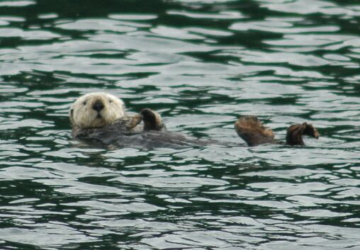
We then went for a 4 and a half mile kayak trip. Which was probably 2 miles too long. Saw one sea otter from a distance. They just float on their back, roll around, and then float on their back some more.


The water is stunningly clear. Bruce or Doug, if you are reading this, the diving would be fantastic.


Brought up the anchor and took a different route out of our lagoon. Again, tricky. Needed to follow our eyes, not the chart or the electronic chart. More or less ‘feel’ your way out, zig zagging around the rocks and reefs.


Went through the Bunsby’s (named after a Dickens novel character) and saw a few more sea otters, again at a distance.


Had a nice – very nice – sail under jib alone. Did just under 7 knots in about 15 knots of wind. Wonderful.


Stopped off at Walters Cove, an Indian village of the Kyuquot Nation. No fuel there, but a small store that has everything from sweatshirts to gardening equipment, rudimentary groceries, fishing tackle, etc all crammed into a very small building.


After sailing with virtually no navigational markers, Walters Cove was a well marked freeway. You need to make some tight “S” turns to get around the rocks, but everything was very well marked. This village will probably stand the test of time where Winter Harbor will likely not. The book says there’s fuel here, but there isn’t. And hasn’t had it for about 20 years. Seems most of the commerce has moved to Fair Harbor, but we’re probably not going to go there. Critical supplies were obtained at Walter’s Cove (half and half and pepper). Critical and VERY expensive ($11 for just those 2 items!).


1600 hours. Well into Kyuquot Sound now, headed for Dixie Cove – supposedly a tight anchorage ringed with old growth trees.


Kyuquot Sound is really pretty. Long fjords punch into Vancouver Island and we can see snowcapped mountains in the distance. As you approach from the ocean, there are reefs all over and even in the clear areas the depths are a little over 100 feet – but once you get into the sound, the depths go to 600 feet or more.


Navigating around here requires attention. There are unmarked rocks everywhere. And in some of the most unlikely places. It’s not particularly difficult, but does require chronic attention and focus. We’re starting to tick off our position every 15 minutes.


1700 hours. Just arrived at Dixie Cove. The book says it’s the most protected and prettiest cove on the entire west coast. And we have it to ourselves. No other boat in the inlet. You actually have to come through one bay, then there’s a small opening and that opens into the inner bay. Pretty cool. Never been logged in here so there are old growth trees ringing the cove. Small old growth trees. Small gnarled old growth with moss. Very green water. All and all a very nice anchorage. We have a heavy metal CD qued up and the speaker covers off should another boat appear.


Over cocktails the balance of the trip takes shape. We’ve been largely ‘making it up’ planning out 2-3 days at a time against an overall backdrop of where we need to be. Our planning was to be in specific areas at specific times, but the actual anchorage is largely day to day. We’ve been out now for 8 days, and have 10 or so left to go. Tomorrow we’ll again head out into the ocean, then decide whether to cut in and take the longer, inner route to Nootka Sound or simply stay in the ocean and make the more direct route. Weather, temperament, stomachs, and inner ears all get a vote…


1840 hours. Just spent happy hour on the bow. The weather is stunning. After fog and rain, this is absolutely what was needed. In a land locked cove all to ourselves in the sun. Unbelievably nice.


Looking around, there are extreme divergent themes. One moment we’re looking at bears, or the nearly extinct sea otters that are making a comeback. Then there’s Winter Harbor – a fading memory of the fishing industry that is, for now, gone. Hopefully wild salmon will again be plentiful, but that could take generations. Then there’s the old growth of Brooks Peninsula and, as I look above the old growth of Dixie cove, see clear cut mountains in the distance. It’s a wild coast, but a worked coast. The working has left scars that will take a long time for recovery.


July 9th, 2011. 1000 hours. Location: 49.51.275N, 127.12.690W. We left Dixie Cove around 7:45 this morning. Flat calm, blue skies. We motored for about an hour to get to the ocean out of Kyuquot sound, then another 30 minutes out into the pacific to avoid the reefs that extend out about 3 miles guarding the entrance.


We set the main and are motor sailing, using the main as a steadying sail against the glassy pacific swells. The wind slowly filling in from the Northwest, but still not enough to sail. As it is we’re making poor time, averaging between 5 and 6 knots.


Our hope is to get into Nootka sound tonight. I’ve always wanted to get ‘up’ to Nootka – approaching it from the North is something I never thought I’d do.


Nootka sound is the site of the Noota Treaty signed in 1790. The readers digest version is this: The Spanash had been working their up from the south, the Russians had been working their way down from the North and the British had been taking potluck, claiming territory where they landed in between. The Nootka tready effectively limited the Spanish influence in the Northwest and divided up Russian and British interests. I’ll read up on the details later and fill in if needed. .


Friendly clove in Nootka sound is also where the first ship was built on the West Coast in 1788. Captain Cook, Captain George Vancouver, Captain Quadra, etc all sailed into Nootka Sound at one point or another. Two hundred and twenty something years later, we will too….


1048 hours. Location 49.48.160N 127.09.373W. Still motoring. Whatever breeze had started now has died. We’re seeing more sea otters. They have a very distinctive shape in the water. They float on their backs and from a distance it looks like a 4 foot log with two bumps on either end. As you get closer, one bump turns out to be their feet pointing up in the air and the other bump turns out to be their head with one impressive nose. The otter is invariably looking at you checking you out.


1132 hours. Location 49.45.104N, 127.05.071W. Finally unfurled the jib. Still motoring, but wind is assisting nicely. I can see how some really don’t like ocean passages. We need to be about 4 miles off the coast to avoid all the rocks. As it is, we’re only in about 200 feet of water, but the coast is foul with reefs. By staying this far out, we’ve got a course clear of all rocks – but we’re so far out there’s little of interest to see. The topography is great, but it’s at a distance.


1215 hours. Just made lunch down below. Normally not very noteworthy, but the swells made it interesting. We have a gimbaled stove, which means it swings freely, keeping the cooking surface level. Nothing else is level, but when you make soup, the soup stays in the pot and keeps nice and level while everything else, including the cook, slides around. The galley is narrow, so you can put your feet well in front of you and lean back to brace yourself. That way you can use both hands – which is nice when your’re trying to make grilled cheese sandwiches. It becomes an interesting mix of balance and trying to figure what’s going to slide around next.


1446 hours, location 49.33.721N, 126.45.470W. Another day in the ocean is coming to a close. We’ve rounded Bajo reef and are headed into Nootka sound. While Nootka is the site of much history, there is no Indian word like “Nootka”. The exact origins are unknown, but apparently mispronouncing Indian names was common, and it was a traditional Indian joke to repeat the mispronounced name exactly as the white guys mangled it. So if Captain Cooks guys got it wrong, the Indians would make a joke about it and reinforce the wrong pronunciation. The joke is permanently recorded on her majesty’s charts.


Jodi now has her sea legs. No repeat of the sea sickness despite being in the ocean all day.


Under full sail in cook channel doing 7 knots, just like the days of old. No engine. I feel like an old salt. Wait, the GPS on my droid says I’m slightly off course….


940pm (or 2140 hours). We pulled into the inner cove behind Critter Cove and there were two floating homes there. So much for a quiet anchorage. We did a 180 and came back to Critter Cove, which is a fishing lodge. Justin, if you are reading this, this is a spot for your Dad. Nice accommodations, friendly staff, and we met 2 guests that have been coming here for 20 years. They use wheelbarrows, BIG ONES, to move the fish around. We talked to one guy and they caught 48 fish in a HALF DAY today. They started at 1 pm. Really nice place and we’re the only sailboat.


The owners have a couple of dogs, both rescued. One was seen by a sea plane pilot. The pilot spotted what he thought was a bear trying to swim across an inlet. Curious, the pilot flew low for a better look. It wasn’t a bear, it was a dog. And it was a large inlet and the dog seemed to be losing the battle swimming across. He landed, got the dog, and that’s how ‘Shrek’ came to the lodge. Shrek died a couple of years ago, but 2 new rescues are there, one of which was Donkey.  A real sweet dog.


0530 hours. One of the downsides of staying at a fishing lodge? They get up early and their boats are noisy. The whole place sprang to life at first light and scores of salmon, who are at this very moment swimming out in the pacific, will, by this evening, become fish filets. I may try to enhance the transformation for one myself later on today…


Nootka, as a whole, is a bit of a disappointment. It’s pretty, but there are a number of clear cuts and it just doesn’t have that ‘special’ feel to it like the Bunsby’s or the Broughtons. I’ve read about this place for years, always have wanted to come here, but now feel a bit disappointed. If you are after fishing, this seems to be one of the hot spots, but for quiet cruising, we’re going to press on.


1500 hours. Location 49.24.903N 126.38.017W. We just sailed for the last 3 hours. Slowly, averaging about 4 knots, but turned out to be a good trolling speed. Armed with a lure recommended by a 12 year old ‘movie star’ at Critter Cove, we landed a nice salmon. It was a bit exciting. We were under sail, and BAM! The line on the reel takes off spinning. I grab the rod and start fighting the fish. At that moment in time a rather impressive sequence of pacific swells starts rolling the boat. Without going into all the details, the fish was successfully landed.


About 15 minutes later, Jodi and I resumed talking to each other.


The ‘movie star’ reference above was due to the 12 year olds cameo appearance in the documentary ‘Luna’. The story about a young killer whale that lived in Nootka sound a few years ago. It became quite friendly – overly friendly – with people and boats. While it make for some great pictures and stories, any wild animal that gets too comfortable with humans is usually the worse off for the experience. Luna was no different and was fatally injured when she swam too close to a Tug Boat propeller.

Thursday, July 7, 2011

July 7th am

July 7th am. Still in Winter Harbor this morning at 9am. Great to sleep in for a change. Today’s challenge is ‘rounding the Brooks’.


The Brooks Peninsula looks as if God, at the last moment, stuck a domino into the otherwise fractured coast of Vancouver Island. It’s a nearly square 10 mile long, 5 mile wide hunk of land that juts out into the Pacific. We’ve got to sail out and around it. Our plan is to sail to the Bunsby Islands where we hope to see more sea otters.


We probably will be out of touch for at least a day. There’s nothing around the Bunsby’s then we’re aiming for Dixie cove – another little inlet with no civilization around. We’re going from marginal toe hold on commerce (Winter Harbor) to true coastal wilderness.


That’s it for now….

Wednesday, July 6, 2011

Winter Harbor -- July 6th

2019 hours. Just ate the rather fantastic vegetarian chili. We are at Winter Harbor, tied to a dock for once watching bears on the opposing shore. We went for a long walk on Winter Harbor’s ‘board walk’. Roughly a mile in total on a small boardwalk built several decades ago. Slippery in spots and somewhat in disrepair. Just like the rest of Winter Harbor. After walking the length of the boardwalk we met an interesting couple from Calgary who were in a folboat kayak and another fellow who had hiked out to Cape Scott. The guy who had hiked out to Cape Scott ran into several wolves out there. Kim, from Calgary, had a ‘First Ascent’ hat on with a Canadian flag sewn in They had trekked in Nepal, kayaked up and down the coast and were very interesting.


Just before we parted company, they cautioned us about starting to walk the boardwalk as there were bears out tonight and several had been seen near the boardwalk.

Gulp, good to know….

Vancouver Island -- July 4th thru 6th

July 4th thru 6th:


Just stopped into Echo Bay, took on water and posted blog.  Echo bay’s store is on a section of what was the Mercer Island floating bridge.  On one of the sections that didn’t sink during that 1989 storm (I still remember looking at the news in disbelief as the bridge sank). Pierre’s Lodge is now there and we talked briefly with Pierre and his wife. Pierre commented on the bull frog and remembered talking with Craig at the boat show.


Last time I was up here it was far busier, but we were there for the weekly Saturday night pig roast. It was packed with boats, mostly power boats. Today there were only a few boats and all of them were sailboats.


We also saw the local bald eagle, “Sally”. She’s been hanging around Echo Bay for 13 years. We got a few shots of her atop a pole on a small island right outside Echo Bay.


If the weather doesn’t change, this evening will be our last day in the Broughtons. One could spend several lifetimes up here and not see it all, but to stay on schedule we’ve got to burn tomorrow getting in to position to go around the top of Vancouver Island. Tomorrow will be the first of several big days crossing large bodies of water. We’ve been spoiled by the calm of the Broughtons. Most of it is quite sheltered from the wind and as a result is delightfully calm. That will change tomorrow.


1600 hours, 50.44.96N 126.39.49W. Joes Cove was our destination of choice. Quiet, protected, and again one other boat in the anchorage so far. An old interesting sailboat. Jodi just went for a kayak excursion. We figured a nifty way of launching the kayaks from the boat. If we lower the davits so the bullfrog is in the water, there’s a slot between the swim step on the boat and the bullfrog. If you put the kayak in that slot, you can have part of your weight on the swim step and part on the bullfrog as you lower yourself in to the kayak. It’s almost graceful. As opposed to the kayaker we saw at Echo Bay. I didn’t see exactly what happened, but heard a shout, a splash and when I turned there’s a guy demonstrating the inelegant way of getting out of a kayak.


July 5, 2011. Location: Joes Cove. It’s 3am and I’m thinking about the rounding. Worried, playing currents and timing scenarios in my head. There’s competing (and mutually exclusive) advice on how and when to cross the Nahwitti Bar. There’s also pressure to get as far down the coast as possible so that once again we can slow down and enjoy a more relaxed schedule.


The next 2 days are part of one long move. First, position the boat to the jumping off point at Bull Harbor then tomorrow get up before first light, venture over the bar, into the largest ocean in the world. The Pacific. No wonder I’m up at 3am worrying.


Later today we’ll cross Queen Charlotte Strait, a large body of water just south of Queen Charlotte Sound. Then we’ll head up Goletas Channel to Bull Harbor, the jumping off point. (Maybe it’s the phrase ‘jumping off’ that has me worried?).


The kayaks are lashed to the deck, fuel cans are tied to the rail, the generator is secure, the boat is ready for heavy weather should we encounter it. Worrying won’t fix anything, headed back to sleep.


0630 hours July 5. Woke to the sound of screaming ravens. There are two of them and we first heard them yesterday. They each have a screech, but each screeched in a different pitch and they alternate. First one, then the other. The sound is an angry and almost human. The effect is like two people with very limited vocabularies yelling at each other. For hours. I have no idea if it’s a territorial dispute or some mating ritual using a sound that could only be pleasing to them. It’s a sound that starts you thinking about a shotgun. We don’t have one aboard, so we’ll crank up the boat and leave the two screechers to their home in Joe’s Cove. Perhaps that was their point all along? I wonder who Joe was and if he ever heard the ravens….


0900 hours.50.45.145N, 126.53.880W We are in Queen Charlottes straits. Were just visited by more dolphins, a couple of which played at the bow for a bit. I think I finally got a decent shot of them while they were underwater looking up at us. Jodi is still waiting for her first whale sighting. Haven’t seen one yet….


1034 hours. 50.46.184N, 127.11.504W. Motoring up the strait. Just past a funny looking small island off Numas Island. Looks like a half dome slightly protruding above the water. The Indian name for it is “Round Side of Hind End”. Or at least that’s what Franz Boas thought they told him in the late 1800’s or early 1900’s. I think the Indian’s were right.


1100 hours. Seas are calm and we’ve now been underway for 4 hours. Breakfast and coffee are over, there’s no wind and no whales. We haven’t touched land for 4 days now. Jodi is starting to crave exercise. We’ve taken a few kayak trips, but nothing really aerobic. So this morning we looked around and invented the ‘stair step at sea’ move. I’m sure it’s been done before, but I just haven’t seen it. We went to the bow and the cabin trunk rises about 15 inches off the deck. A step. 80 steps is 100 feet of vertical elevation. Start stepping. We did 125 feet of vertical in a few short minutes. Felt good. Will do much more of that. A couple of hundred feet of vertical every couple of hours should do it….


There are very few boats around. The straits are about 15 miles wide and we can see 20 miles of its length in front of us and another 20 miles behind us. That’s roughly 600 square miles of water with perhaps 3 vessels widely spaced apart. I recall much more commercial traffic up here in previous years. The economy? Fuel prices? Declining fish stocks? Something else? All of the above? Don’t know.


1330 hours. Location 50.50.232N, 127.42.367W. Well into Goletas channel now. Fairly boring day of motoring. We’ve been dodging drift for a while. Jodi is getting good at it. We are approaching Bull Harbor and can now see the Pacific Ocean. It’s still calm as we’re still in the lee of the north end of Vancouver island, but we’re getting very near the top of the island. We’re passing abeam of Sushartie Bay. A long time ago one of my buddies saw some Killer Whales right about here and jumped in the boston whaler for a close look. He got some great shots and nearly climbed over the back of one of them (and for anyone reading this that was over 30 years ago under a different set of sensibilities. I like the US 200 yard buffer more than the Canadian 100 yard buffer and a good telephoto is better than harassing wildlife).


Vancouver island, for all its majesty, wimps out at the top. For all the mountains that form its backbone, the northern end gently dips into the ocean and extends out a bit forming Tatnall reef and the bar.


Just as we begin to feel the swell from the ocean, we duck into Bull Harbor. Two other cruising boats here, we find a nice spot, drop the hook, and we’re here.


Jodi presents me with a choice. Vegetarian chili or fresh fish. I say ‘fish sounds pretty good…’. Her eyes cast a glance at the unused fishing pole affixed to the backstay. Uh oh. Pressure is on. For those that know me, fishing has never been my strong suit. I fished as a kid, but never really pursued it the way Bruce or Sheldon have. Because I cruised with both, fresh fish really wasn’t a problem. Both were born with that ‘hunter gatherer gene’ that some people, mostly guys, have. They venture out with appropriate ‘gathering gear’ and gather. It used to be rocks, spears and snares. Now it’s shotguns, rifles, fishing poles, crab pots and shrimping gear.


In any case, if you are fortunate enough to have them as friends, fresh food is never far away. It’s terrific, and over the years I’ve gotten used to it. If it involved diving, I can spear fish as good as the next guy (Bruce will forever remember the flash of my knife when we were 60 feet down and I pithed his nice big ling cod that he had shot in the gut). But on top of the water my fishing skills are not that great. In short, they suck.


Which is why I had two alternating thoughts when her eyes went to the fishing pole. One was that vegeterian chile wasn’t that bad. Especially hers. It’s pretty good. The other was one of terror. The pressure was on. She raised an eyebrow. Nuts. I had to provide.


Worse, she wanted to go with me. Heck. Humiliation was just around the corner. I could feel it.


After all that, we jumped in the dinghy, I picked a spot that seemed likely and before too long. Bam. Two fish were in the boat. Success!!! A fresh fish dinner was assured. A good omen. Perhaps ‘jumping off’ tomorrow would be alright afterall. The dolphins had played with our bow, a traditional good luck sign and I’d caught a couple of fish.


Its 930. 2130 hours in nautical speak. It’s still light outside. The weather up here is different. Just before dinner time the visibility was about 100 yards. A fine mist, bordering on fog, blanketed the harbor. We couldn’t see much. Fast forward 30 minutes. Brilliant sun – sun with authority. It was beautiful for about an hour. Then the mist returned. We’re getting the boat ready for tomorrow. The drill. Lash down everything, store everything. Nothing to roll or rocket around if we hit big waves.


There are two other boats in the harbor and both are going around. Departure time is around 4am. I would have picked about a half hour later, but there’s comfort in numbers. Alarm is set for the ungodly hour of 345. We’re ready. Just need to pull up the anchor and point the bow towards the bar, then the Pacific. The first part of the plan – screaming up the east side of the island and spending time in the Broughtons, worked. We wish we could have spend more times in the Broughtons, but time won’t allow it. Future years. Now to execute the next part of the plan…..


July 6th. 0345 hours. Up before dawn. There’s movement on the other two boats, they are awake also. For me, it’s still too dark to venture out. There’s no benefit – slack is still an hour and a half away and there’s an adverse current. I make coffee, crank up all the systems – GPS, laptop, radar, fathometer, and the VHF. And wait.


The trawler makes the first move, raises his anchor and disappears out of the harbor into the gloom. It’s foggy.


Finally there’s a bit of light. We need to leave as well. The other sailboat in the harbor has been up for sometime. We talked to him yesterday and he too is going around. We raise the anchor and Jodi steers as I stay out on deck for better visibility. The harbor behind us disappears. We are in the fog. The radar shows no targets in front of us and a blip appears behind us. The other sailboat. I can’t find the trawler ahead of us on the radar.


We head towards the infamous Nahwitti Bar. As we approach the bar the depth comes up dramatically. We go from 400 feet to about 60 feet in just a few boat lengths. We’re at the bar, boat is ready for anticipated waves --- but they don’t really appear. We can feel the ocean swells, but the bar is quiet. Another non- event. Good.


0530 hours. Jodi and I are talking in the cockpit, enveloped in the fog. I look behind her and off to starboard by about 50 feet a Minke whale surfaces. It surfaces once again and swims out into the fog.


The water is glassy smooth with ocean swells. It’s foggy, and there are hundreds – thousands – of birds floating on the surface. They dive underwater, take flight, there’ll all busy and the sheer number of them is awesome. Our world is roughly a 200 yard circle. We can’t see land.


0718 hours. Visibility has improved a little bit. Still can’t see land, but our world has grown to perhaps a mile in all directions. Swells are getting larger. The true ocean is getting closer. Were not quite yet to cape Scott, but getting there.


“Butch Cassidy” is the sailboat that left the harbor when we did. Total stranger, but we’ve been cruising side by side for a couple of hours now, he off my port beam by just under a half mile. Sometimes I can see him, other times he’s the only blip on the radar, but there’s some comfort that another boat is out here.


Just saw my first real Sea Otter. There’s plenty of river otters around, but this guy was large – about the size of a seal, but definitely an otter. The were hunted out here nearly to extinction, but are making a comeback….


0830. Just rounded Cape Scott. That’s the good news. Bad news? We’re in the slop. Not enough wind to heel us to one side, and lumpy irregular waves on top of ocean swells. Jodi is turning an odd shade of green. I did raise the main as a preventive measure before we left and while it does help, there’s still a lot of movement. Going down below is difficult at present.


The only good news is that we’re making decent speed. Above 7 knots, which is a good thing, I’d give Jodi some advise, like ‘look at the horizon’ – but there isn’t any horizon. The gray water melts into the gray fog at some unknown distance.


0934 hours Location: 50.39.140N 128.25.500W. There simply is not much charitable I can say about the Northwest end of Vancouver Island. An inhospitable lee shore full of reefs. Sea is confused. Jodi is resting.


1000 hours: ‘Butch Cassidy’ stayed inshore and went to Sea Otter cove. We’re pressing onward to Winter cove. There are no blips on the radar anymore. We have this stretch of the pacific to ourselves. I can see why. No one else would want it. Uncomfortable and boring. Still foggy, haven’t seen land since we left at oh dark hundred….


1030 hours: We are not alone. I kept seeing an intermittent target on the radar and as the fog is clearing, there’s another sailboat inshore of us. He must have left from Sea Otter cove this morning.


1045 hours The breeze is filling in as the fog lifts. The ocean waves are becoming more rhythmic and the motion of the boat is less chaotic. Jodi is feeling better. Hopefully we can sail soon.


1215 hours. Settled into a comfortable motor sail. Wind just hasn’t filled in yet. Blowing perhaps 10 knots from the NW. We went from seeing no one to seeing dozens of small fishing boats out of the Winter harbor area. Must be a lot of salmon around. We saw a couple of them jump out of the water near the boat. The rounding and the first day are nearly behind us. All and all things went OK, although sloppy seas in the fog aren’t very fun.

1320. Location 50.27.936N, 128.01290W. We’re now well into Forward inlet, heading towards Winter Cove. Well in the lee of Cape Parsons. Looks like we’re headed into another rain squall, but the seas are calm for now.

Monday, July 4, 2011

Vancouver Island Days 4 and 5


1520 hours. Location: 50.46.007N 126.10.646W. Took off from Lagoon Cove shortly after noon. Late start compared to what we’ve been doing. Went up Tribune Channel and ran into a herd (pod? Bunch? Gaggle?) of Pacific Whitesided Dolphins. There may have been 20 or so of them, surfacing and apparently feeding. Unfortunately they took no interest in the boat and didn’t play with the bow wave.


We both keep thinking about that close encounter with the bear. That was pretty cool. She (we think it was a she and we were close enough to see what wasn’t there…)

was walking along the shoreline and came to vertical cliff. Without hesitating, she waded into the water and started swimming, snorting while she did. She swam for probably 50 yards or so then emerged from the water dripping wet.


We’ve also seen a number of young seals perched on logs out in the water. Don’t think I’ve seen that before.


Tribune channel is alternately beautiful, majestic, and scarred. Fjord like, with several waterfalls cresting down steep slopes. Then you’ll come around a bend and see the scar from a clear cut.

Water is bathwater calm and a deep green, reflecting the trees that carpet the steep slopes. Tried to frame a spouting Dolphin with a waterfall in the background. I don’t think it worked, but the memory will stick for a while.


1830 hours. 50.49.21N 126.17.40W. Wahkana Bay. One other boat in the anchorage. A big one – about 80 feet or so.


We tried to get some more dolphin pictures. By the time they came close, I had the wrong lens on. I think all I got were splashes. They came up and visited, but didn’t stay long.


Took a long kayak paddle tonight. Beautiful bay – lots of evidence of long ago logging.


Dinner is barbequed pork with cole slaw. Fleetwood Mac is playing on the stereo. Life is pretty good at this moment…


July 4th 0800 hours. Coffee it the cockpit. The only other boat has left the bay, leaving us in splendid solitude. No man made sounds. We can hear dueling woodpeckers at opposite ends of the bay and the stream that feeds into the bay offers some natural white noise. So far, Wahkana Bay is our favorite. Quiet, protected anchorage.


When we pulled up the anchor, we did have a visitor which we returned to the bay....


1000 hours. We reluctantly left Wahkana Bay and motored over to Kwatsi Bay. There’s a small marina there and it looked nice enough but wasn’t sufficiently enticing to stop. 


Tom, if you are reading this, we’re seeing a lot of drift. 3 observations. First, there’s a lot of it. Big logs, small logs, and branches. It lays in the water in bands and you have to pick your way through it. Second, it looks like whatever caused the drift was recent and violent. Either shreds from logging or the result of landslides. There’s evidence of landslides all over up here. Some recent, some long ago, but with the steep, steep slopes it makes sense. Whatever the cause, it looks like the branches and tree trunks were ripped from where they were with great force. The last observation is that because they’re so recent the wood is green and heavy. Many of them float low and are difficult to see. We’ve bumped 2 so far. Nothing serious and they were relatively small.


Just got buzzed by a few more dolphins. You can clearly see them underwater when they swim under the boat. The aquatic version of a dog chasing a car. They seem to really like Tribune Channel. We’ve probably seen close to a hundred of them so far. Some seem to be pretty playful and occasionally leap completely out of the water. I stopped trying to get a picture of it because it happens so fast and you never know where they’ll be, which one will leap or when they’ll do it.

Sunday, July 3, 2011

Morning Bear


Vancouver Island – Day 4


Morning in Lagoon Cove. This morning we had planned to take a hike after breakfast, but those plans were dashed when a bear was sighted on the beach headed for the resort. If it was a black bear, it wouldn’t have been that big a deal. But it was a large brown bear. With a hump above the shoulders. Possible Grizzly. We were strongly advised not to get off the dock, so we jumped in the little boat and went hunting. We found her….


This may be the last post for a while. We’ll try to find internet access, but now it’s out into the wilderness. Wonder what’s out there…..

Vancouver Island - Day 3


JULY 2nd. Early morning departure at first light. Anticipation. The slack at Seymour Narrows is 609am and we have roughly 6 miles from the anchorage to the narrows. We have about a 15 minute window to transit the narrows. George Vancouver once called Seymour narrows ‘the most vile stretch of water in the world’. It’s notorious for its incredibly strong currents. Faster boats have a wider margin of safety, slow boats like ours need to nail the slack. According to the Canadian Hydrographic Service “small vessels have been capsized with loss of life even near slack water in reasonable weather conditions. All crew members should be alert and ready to cope with any emergency.”


I’ve had a quarter cup of coffee, still blinking because it’s 5am and Jodi is sound asleep in her bunk. Perfect – let’s go.


I’m typing as we head into the narrows. It’s another gray morning, but fairly calm except for the small whirlpools and rip tides. The last evidence of a dying flood as we approach slack. Incredibly, even though slack is only 50 minutes away, we’ve got a 3 knot current against us.


Now we’re approaching the narrows – about a mile ahead of us. Right on schedule, the water is calming and the whirlpools are fading. Slack. One boat is already through, I’m next and there’s one behind me. The sun is rising over the mountains. Beautiful.


The passage itself is anticlimactic. Just as it should be.


0700 hours, July 2. Just about to head out of Discovery Channel into Johnstone Strait. First bear sighting. Strolling on the beach looking for breakfast – a beachcombing bear. Couldn’t get close enough for a decent picture.


0946. 50.24.081N, 125.55.123W. The Ebb is pushing us north. We hit 12 knots at one point. So far, making great time. Just got buzzed by 3 Dall’s porpoises. They streaked towards us, swam by our keel and were gone in a shot. I could clearly see them underwater as they zoomed by.


Johnstone strait is tricky to navigate. It’s the main thru way for all sorts of vessels and there are specific strategies to navigate them depending on how the current is running. If there’s a wind, Johnstone strait can be a nightmare. I had my courses set up on the laptop, but I watched a commercial fishboat in front of me. He wasn’t steering a straight course and it occurred to me he’s reading the water as he’s going along. These guys know their stuff and with fuel prices the way they are, there’s a reason for every move. He was watching the backeddy line and staying to one side of it. I tried it and picked up nearly 2 knots. A boat behind us was following the book. We handily beat him even though he should have been a little faster. The fishboat taught me a good lesson.. Currents don’t go in straight lines. When playing the currents, neither should boats go in straight lines.


We made very good time up Johnstone straight. Need to put the totals together, but I bet we averaged nearly 9 knots. Not bad for a 6.5 knot boat….


So good, in fact, that I just killed the motor. The wind is filling in from the east and we are sailing at around 5 knots. Very quiet without the motor!!


Well that didn’t last for long. 30 minutes of quiet, then had to crank up the motor again. Got out of Johnstone Strait and went through Chathom Channel. Tiny little channel, but looks more challenging than it is. We’re getting close to our destination for the night, Lagoon Cove. Need to squeak through the ‘blow hole’ then we’ll be there.


The ‘blow hole’ is a small channel just before you get to Lagoon Cove. Slow and easy and we’re through.


I forgot how nice Lagoon Cove is. It’s the most southern ‘resort’ in the Broughton Archipelago The ‘resort’ is a house, a boat shed, and a dock with some floating buildings attached. Bill, the owner, greeted us at the dock and gave us an overview of local news. Which included the exciting outcome of yesterday’s annual running of the crabs. Featuring 4 different heats, heavy betting, and over 60 crabs racing as if their lives depended on it. Which it did. The winning bet was placed by a 10 year old kid, winning the whole betting pool and letting the winning crab go free. Most of the remaining crabs were eaten last night. The left over crabs are tonights meal. We learned later that last year’s winning crab was not so lucky. The winner of the betting pool decides the winning crabs fate – the 10 year old had compassion. Last year’s winner surmised that the winning crab was in awesome shape and should be the best tasting crab of the bunch.


Bill reminded us that cocktail hour starts promptly at 5pm and all guests were invited to bring appetizers to the party. Bill provides the prawns, crabs and stories. We have just enough time to straighten the boat, take a hike, and be back for happy hour. Perfect.


Happy Hour at Lagoon cove is far more than that. Years ago, a good friend of mine stopped by Lagoon cove and heard about the appetizer party. He prepared a pretty good one. He was proud of what he had prepared. He walked and plopped down his dish. The next guest? Graham Kerr, the galloping gourmet. Also a sailor. You never know who’s going to show up.


We didn’t see any celebrities – at least none we recognized. But the food! Wow.


Bill told some stories about early Broughton history, and the names of certain coves and inlets. Turns out one was named after a fellow that moved his wife to the cove. His wife had a brothel and loggers from miles around would visit. Locally (not on the charts) the point just outside the cove is named ‘pecker point’ (his story, not mine!).


Bill also told another story dating back to the early ‘20’s. Seemed this young fellow just out of school was looking for a job. It was September and he was going door to door and he walked into the headquarters for a timber outfit. The guy behind the desk said ‘heck, winter is coming – we’re laying people off, not hiring! At which point the kid turn around with a defeated look on his face. Just before he got out the door, the guy behind the desk said “hey, we do need a care taker for the winter at our camp up in Knight Inlet”.


The kid said, “well, maybe, what’s involved?”. He was told the responsibilities and the salary, and the kid says ‘ok, where is it?”.


The guy behind the desk pulls out a chart and shows him the Broughtans and were Knight Inlet is. The kid says “gee, that’s looks way out of the way. Won’t I get lonely?”. The guy behind the desk smiles and lies. He says ‘see all this water? There’s boats and people going by all the time. Plenty of people”.


So the kid signs on, gets a lift from a tug and in mid October becomes the caretaker of the logging camp at Knight Inlet.


For the last 2 weeks of October, no one stops by.


November. No one stops by.


December. Not a soul.


Ditto January and February.


Finally in mid March, there’s a banging at the door of the caretakers cabin. There’s a voice that says ‘hey anyone in there??”


The kid answers the door – after nearly 5 months of solitude he’s desperate. More than desperate for human contact. He opens the door and there’s a trapper. A huge guy. 6’5” at least and is a mountain of a man. Hasn’t seen soap all winter, smells like the animals he traps, but desperate for human contact, the kid invites him in.


The trapper says ‘I just want to welcome you to Knight Inlet. You are new in town right?”


The kid nods, but says “I’ve been here 5 months since last October, so I’m not exactly new, but thanks for the welcome anyways”.


The trapper doesn’t even blink. He says “hey, I’d like to invite you to a party”


The kid, desperate for any human contact, says “Party? Really, a PARTY??” I’d LOVE to go!!”


The trapper says “Great! But there’s one thing I need to warn you about. There may be some dancing”.


The kid says “Dancing? That’s ok, I’m a good dancer. I like to dance. Dancing is great. I can’t wait to dance”.


The trapper says ‘Great, but there’s something else. There could be some drinking”.


“Drinking?” the kid says. “After 4 months of not seeing a drop of alcohol, may be a drink or two would be just fine. Sounds great!!”


Then the trapper says “Ok, but there’s something else. There may be some fighting”.


“Fighting?” the kid says weighing the prospect of actually talking to other human beings after a long, cold, lonely, winter vs fighting. He decides and says “fighting is OK. It’s a party, fights break out. I can take care of myself. I’m in – when and where is the party?”


The trapper says “Great!. But there’s one last thing. There could be some sex involved”.


The kid says ‘sex?’ After 5 months he can’t wait. He says “I’M IN! What do I wear???? I really want to go, but is it formal? Casual? What should I wear???”


The smelly, huge trapper looks the kid up and down and says “what you have on is just fine. After all, the party is just you and I.”


Those are the stories you hear up in the Broughtons…..